
New release of MapStore with Annotations and Quick Search

Dear Reader,
we are pleased to announce release 2017.05.00 of MapStore, our flagship Open Source webgis product. The full list of changes for this release can be found here, but the most interesting additions are the following:
- General Review of Map Layout, reorgainizing tools in the bottom-right corner and adding the footer.
- TOC UI Review, so that now the map’s table of contents is organized in cards.
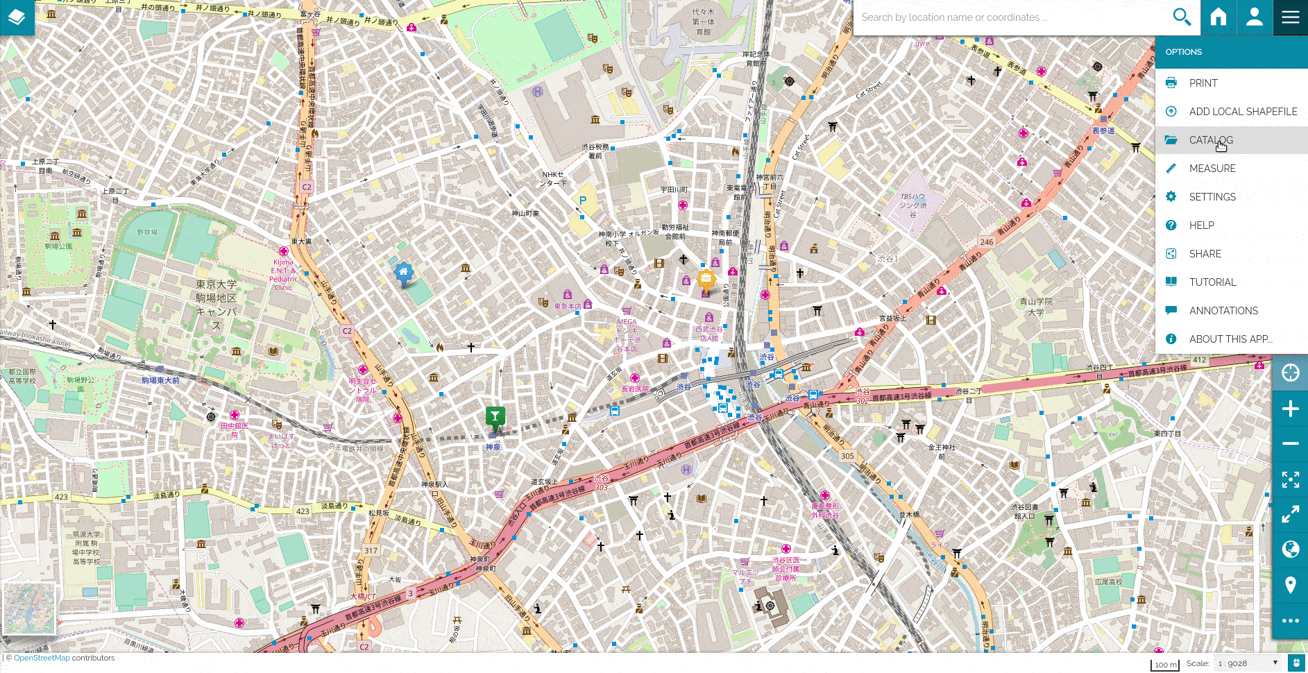
- Catalog UI Review, to make the catalog widget more intuitive. You can add as many sources as you want and save them in the map.
- Initial Support for annotations, now you can quickly annotate the map with markers having also the ability to customize their style and description.
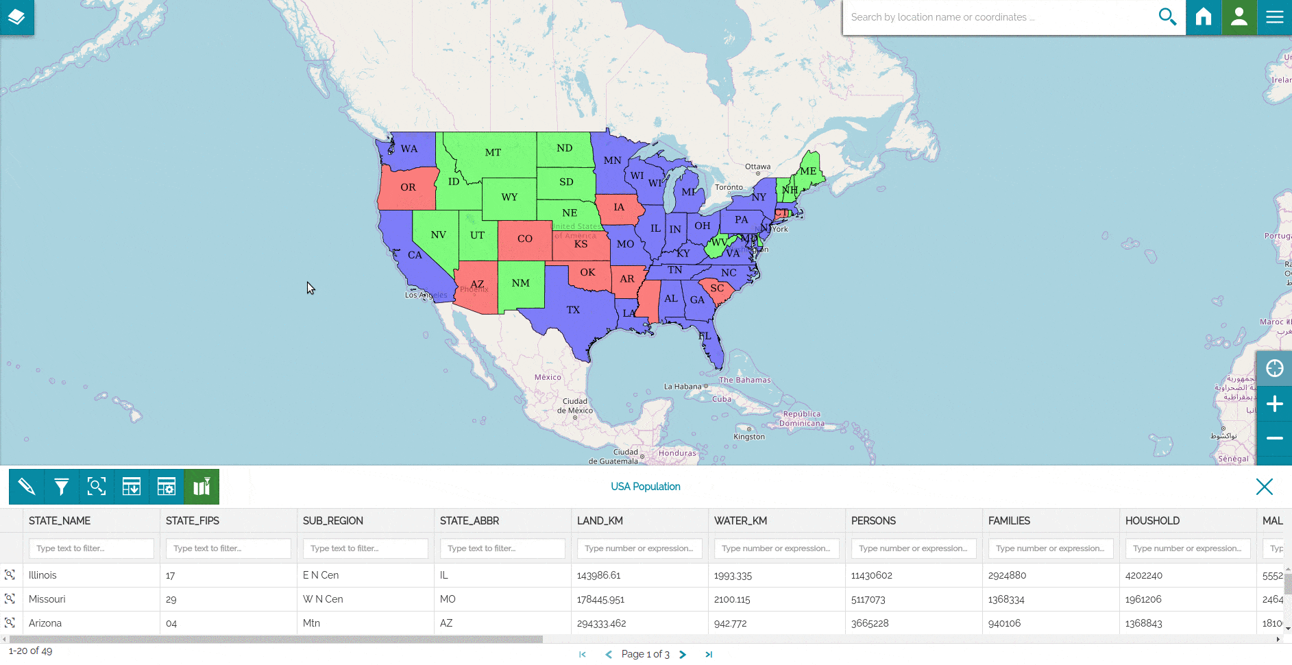
- Quick Filter on Feature Grid, now you can search directly from the featuregrid without opening the query panel. You can also synchronize the content of the map with the filtered data.
General Review of Map Layout
We have started an in-depth review of the map look&feel; now the scale and coordinate indicators are placed in a footer, together with the attribution. The table of contents has been reorganized, allowing filtering and grouping all the layer tools in the top toolbar; the layers are now organized in cards that can be expanded or collapsed to see the legend.


The catalog widget has also been reviewed. Now you can add OGC CSW, WMS, or WMTS services in a more intuitive way and store them in the map configuration for later reuse.

New Catalog UI

Add Catalog Services
Initial version of Map Annotations
We have implemented a first version of map annotations that can be used to implement markers. You can easily add to the map your own markers, customizing content, icon and color. You can use this functionalities to mark your favorite places, the places to visit for work or whatever you want.
Annotations are saved in the map context, hence you can share them with your friends, coworkers or the users of your geoportal. More feature and look&feel improvements will be performed in the next releases.
Annotations
Quick Search
We have been struggling over the years with complex interactions with visual query builders to filter data exposed via the OGC WFS services. We have therefore decided to try and build a simplified filtering capability to easily filter vector layers directly from the data grid column headers. You can now enter text or insert a formula (like > 10 or <= -23) right in the header and see the data grid filter rows automatically. You can also synchronize the content of the map to match the content of the data grid.
Quick Search and Map Sync
Future Work
We have great plans for the future which translates into many new features in the working. Just to give you a little preview of an interesting one, for the next release we are implementing charting capabilities for vector layers directly inside the map. Here below a preview.

Preview of Charts functionalities
In addition, there are other things in the pipeline, in sparse order:
- Integration with GeoNode
- Integrate styler for GeoServer
- Revamp of the Catalog Widget to make it more usable
- Support for layers with TIME
- Support general map annotations, beyond simple markers
If you are interested in learning about how we can help you achieving your goals with open source products like GeoServer, Mapstore, GeoNode and GeoNetwork through our Enterprise Support Services and GeoServer Deployment Warranty offerings, feel free to contact us!
The GeoSolutions team,
