
State of GeoNode Free Webinar – Release 3.2
Dear Reader,
one of the core technologies in a Spatial Data Infrastructure (SDI) is a catalog. Catalogs have become more powerful since now days they also play the role of Geospatial web portals. Portals are providing the virtual place for not only users to discover, access, view and download data, but also for data providers to have a central place to post data and create immersive stories in a collaborative environment.
With GeoNode data providers can upload data (e.g. shapefile, GeoTIFF) and in immediately that data will be available via open standards. It also allows to register services form external systems (e.g. WMS from ArcGIS Servers). GeoNode is a content management system for geospatial, build on open standards and open source. It powers lots of Spatial Data Infrastructures in the world. For example we have installed GeoNode in various countries (Italy, Germany, Norway, USA, Switzerland, Finland, Malaway, Afghanistan, Mozambique, Ghana, Uganda, Nepal, Madagascar, Fiji and more). The World Bank, in particular, has greatly supported its development and even published a report about the return over investment they encountered when investing in the development of GeoNode. A great blog about it is available at the World Bank web site.
GeoNode 3.2 will be released in the next days therefore we are hosting a free webinar on Wednesday April 28 that provides the information about this new release and will allow enthusiasts and users to interact with key GeoNode developers. Some highlights of what’s new are listed here below.
Libraries updates
GeoNode 3.2 now relies in new libraries: Python 3.7+, Django 2.2.16, GeoServer 2.18, Dockerfile 3.4. These updates are crucial to security and ensure proper functioning over time of GeoNode.
Enhanced MapStore viewer
The integrated MapStore viewer has been updated. It now allows to save Map Preferences, it provides a visual styled editor (as shown below), as well as, an improved Map Save Widget, specific for GeoNode. Moreover, the MapStore configuration subsytem for GeoNode has been vastly improved.

Visual Styled Editor for GeoNode
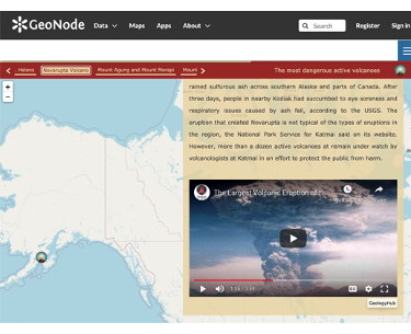
Rich views via GeoStory functionality
GeoStories are now an integral component of GeoNode, enabling rich display of geospatial data along with rich text, documents and multimedia. Click on the image below to see an example.

GeoStories in GeoNode
Customizable GetFeatureInfo via visual templates
The capability to create sophisticated templates to easily customize the display feature information when using WMS GetFeaureInfo request has been added to GeoNode, as per GNIP-77. This allows end users to turn links to images, URLs, audio files and videos into a nice content as shown below.

GeoNode GetFeatureInfo with advanced templating
An easy to use GUI has been provided to define the template to be applied in the viewer (i.e. MapStore), see below.

FeatureInfo Template Editor
New REST API
A new programmatic way to interact with GeoNode via a new REST API is under active development and a first version to power a more modern homepage has been released. You can see it in actions in the new UNESCO WINS portal.

UNESCO WINS GeoNode
Improved upload page
We have started an extensive work towards improving the upload of resources both manual as well as programmatic. A first page of enhancements has landed as per GNIP-84, which provides better control over upload sessions, first of all the ability to terminate sessions after we have left the upload page.

Upload page in GeoNode
Ability to append data to an existing vector layer
It is now possible to upload vector data and append it to an existing vector layer.

Appending data in GeoNode
Advanced map legend
We have reworked the way we show legends for maps in GeoNode as per GNIP-85 in order to make more coherent for maps with many layer, as shown below.

New Map Legend Widget
Core cleanup
As per GNIP-81 vast code clean up on the core of GeoNode has been performed to improve maintainability. Functionalities that were not maintained have been removed like GeoNetwork support, QGIS-Server support and the SPC Docker installation have been removed to reduce the footprint of the codebase and to improve its robustness.
Brand new thumbnail generation pipeline
We have been working on replacing the old thumbnail generation pipeline with a brand new one that uses a more modern approach and will bring more stability in the long run.
Custom controlled vocabularies
A custom controlled vocabulary, can now be used in metadata fields, including capability of uploading RDF Thesaurus via the user interface.
Updated documentation
The documentation was also updated. My two favorites are Improve GeoNode OpenID SP Protocol in order to be able to provide access to external clients and How to Upgrade from 2.10.x / 3.0.
I just highlighted my favorite enhancements. To learn more about GeoNode 3.2 and enjoy a 20 minutes of Q&A time with our lead GeoNode Lead Developer Alessio Fabiani, our Technical Lead Giovanni Allegri as well as other Project Steering Committee Members like Florian Hoedt and Toni Schönbuchner. I cordially invite you to a free webinar on April 28 at 11:00 Eastern Time / 3pm GMT by registering at the link below!

Hope to see you virtually on April 28, meanwhile stay safe and keep strong!
Cordially,
Luis
