
HEV-E: leveraging on GeoNode to explore data for disaster risk management
Sharing data and information related to risk management is a stringent necessity. Natural events have an ever increasing impact on global population and assets, mostly in areas with reduced capabilities to deal with emergencies. Disaster management, prevention, and planning activities require access to the most up to date and detailed information available for a geographic area. Often data resides in some remote corners of the web hardly discoverable or, in the worst case, is kept segregated in local storage reducing or completely cancelling its value. Moreover data often lacks fundamental information (metadata) regarding its contents and formats.
The GFDRR group of World Bank tackled this within the second round of its “Challenge Fund” initiative. One of its goals was designing a common data model to store and share data about exposures, hazards and vulnerabilities, and a web platform to ingest, explore and download these data.
GeoSolutions was committed for its design and development. The project has been based on a lightweight User Centered Design approach, doing interviews to stakeholders and collecting suggestions from domain experts. The results of this phase was a mockup that in a few weeks has become the base of the HEV-E Platform.

HEV-E mockup
Although being in its initial phase a first release of the platform was released a few weeks ago. New and improved functionalities will be added in the future. Thanks to a great set of tools we were able to go online in a couple of months:
- GeoNode: it provides the metadata services the and layers views management
- Geoserver: (OGC) map services and layers styling
- Django: a dedicated project has been implemented to expose custom APIs and extending GeoNode functionalities
- MapStore and React: the frontend is completely based on MapStore (our flagship frontend framework) and new specific React components
The final result is a Catalog that let users explore Exposures, Hazards and Vulnerabilities functions currently available (for the moment just a small sample dataset).

HEV-E Homepage
The original dataset are split into single layers, that can be searched and filtered through the HEV-E catalog frontend. From the catalog a preview of the geographical area covered by the layer, and a preview of the layer content themselves, is shown on the contextual map. A user can add a layer to the map, to keep it around while continuing navigating through the catalog. Being in sync with the area currently shown on the map, the catalog helps the user obtaining only the relevant layers for the context currently explored.
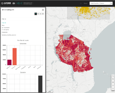
For each layer a Detail view provides insights on the specific layer’s contents, according to the layer type and contents. As an example, for exposures a chart with the number of occurrences by construction material or type of occupancy is shown.

HEV-E catalog search
During the exploration the user is able to add each layer to a Download area, a functionality is similar to common e-store “shopping carts”. From this area layers can be selected to submit a download orders, that will be managed by the HEV-E platform asynchronously. A notification or an email will be sent to the user to communicate when the requested files are ready for download. A URL to the Shapefiles, CSV or GeoPackage (the format depends on layer type and user preferences) will be provided for direct download.

HEV-E Download Area
The project has proved again the benefits of adopting mainstream software integration to compose advanced custom applications. GeoNode‘s standard functionalities cannot cover all the specific needs and often a tailored user interface with custom tools and functionalities are required, but it can be adopted as a “backend service” with a bespoke frontend and, in this case, a dedicated backend API.
We wish long life to HEV-E and we hope to continue our contribute to it and its social goals!
Last but not least, we would want to thank the GFDRR group at the World Bank which provided the funding for this work.
If you are interested in learning about how we can help you achieving your goals with open source products like GeoServer, MapStore, GeoNode and GeoNetwork through our Enterprise Support Services and GeoServer Deployment Warranty offerings, feel free to contact us!
The GeoSolutions Team,
