
JRC portal for the Danube area implemented in collaboration with GeoSolutions
Recently the DRDSI (Danube Reference Data Infrastructure and Services) portal was launched to the development of which staff of the Joint Research Centre (JRC) together with staff members of GeoSolutions have contributed.
The JRC, with the support of the scientific partners of the countries of the Danube, has launched the project to develop the Danube Reference Data Services and Infrastructure (DRDSI) that will facilitate access to scientific datasets comparable and harmonized on various issues related to the region, in support of the EU Strategy for the Danube Region (EUSDR)
The Joint Research Centre of the European Commission coordinates this initiative, whose main objective is to provide scientific support for the EU Strategy for the Danube Region (EUSDR), focusing on four areas of priority:
- Environmental Protection
- Irrigation and agricultural development
- Navigability
- Energy Production
In addition, the initiative also aims to facilitate the development of Smart Specialisation Strategies to encourage innovation in the Danube region.
The initiative comes from a close cooperation between JRC and important scientific partners from the Danube area. The project has been developed with an integrated approach, organized by thematic areas (Flagship Clusters); in this initiative will be collected data and identified scientific skills that will help to identify the policy measures and the actions necessary for the full implementation of the EU Strategy for the Danube Region.
The portal DRDSI offers a wide range of features. It is entirely based on open source software, it provides the user with cataloging and metadata searching functionalities (by using CKAN) while providing the ability to interface with advanced features for browsing geographic data on the map (with the support of MapStore).
The peculiarity that underlies the entire infrastructure, consists of the fact in the integration of separate components with the objective of providing a single, slender point of access to data for all the involved regions . The main objective of the project is to harmonize the set of services and information provided in a intuitive way for the user. The MapStore framework (versione 1.6) was appropriately updated for this purpose to ensure:
- Tools to inform the user about the loaded map services status and the relive messages

MapStore at work for map preview
- Easy-to-use functionality of maps embedding and preview

MapStore based map preview
For the publication of the metadata aggregated from the various sources in the area the CKAN framework (versione 2.2) has been equipped with special additional features such as:
- Extension for geographical research.
- Extension to support the Harvest CSW.
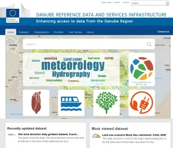
- Extension for customization of the entire graphic interface in order to maximize their effectiveness in relation to the context of use (see figure below).

DRDSI Portal homepage
- Extension for the integration of the framework MapStore as cartographic display of preview (simple and advanced) of associated data. This component has been developed with the intention of providing a quick, easy, and customizable access to maps. The support for a shopping-cart allowing the selection of the maps that the user wants to see once the search has been made is also available.

DRDSI Search functionality at work
All the developed features are available as Free and Open Source software and are released in their code repository or in the GitHub di GeoSolutions.
The GeoSolutions team,