
MapStore Release 2020.02.00

Dear Reader,
We are pleased to announce the release 2020.02.00 of MapStore, our flagship Open Source WebGIS product. The full list of changes for this release can be found in the GitHub Project. This blog highlights the most interesting ones.
Important changes for this release
This release comes with many new features and functionalities. The two important ones are:
- GeoStory: you can now create and share fascinating, interactive stories combining text, interactive maps, and other rich-multimedia content. Special thanks to the MapStore team for this.
- Application Contexts: as administrator you can now build and configure your own map viewer, share it and create maps on it. Special thanks to the MapStore team for this too!
Other new functionalities include:
- Click Filtering: When a user clicks on a vector feature on the map, the attribute table is filtered accordingly.
- Measurements: A user can now measure distance, area and bearings by just drawing on the map.
- Import/Export: A user can now import and export Web Map Context (WMC) files, that allows to share a map context between clients. The file includes information like list of layers, projections, coordinates, zoom and extension.
- Catalog Tool: MapStore connects to a catalog to find services and get data or images to be added to the viewer. Tile Map Services and Web Feature Services are now supported.
- Identify Tool: The identify popup provides more information about the feature on the map. A user can also now switch to edit mode by opening the attribute table.
- Layer Settings: A user can now edit the legend size in MapStore, adjusting to the user needs.
Storytelling with GeoStory
Yes, finally MapStore is able to create also Stories or, better than that, GeoStories!
GeoStory is a tool that allows to create inspiring and immersive stories by combining text, interactive maps, and multimedia content (e.g. images, video or other third party content). Through this tool you can easily tell your stories on the web, publish them, and share them. Stories can be shared with configured user groups in MapStore or publicly to everyone around the world.

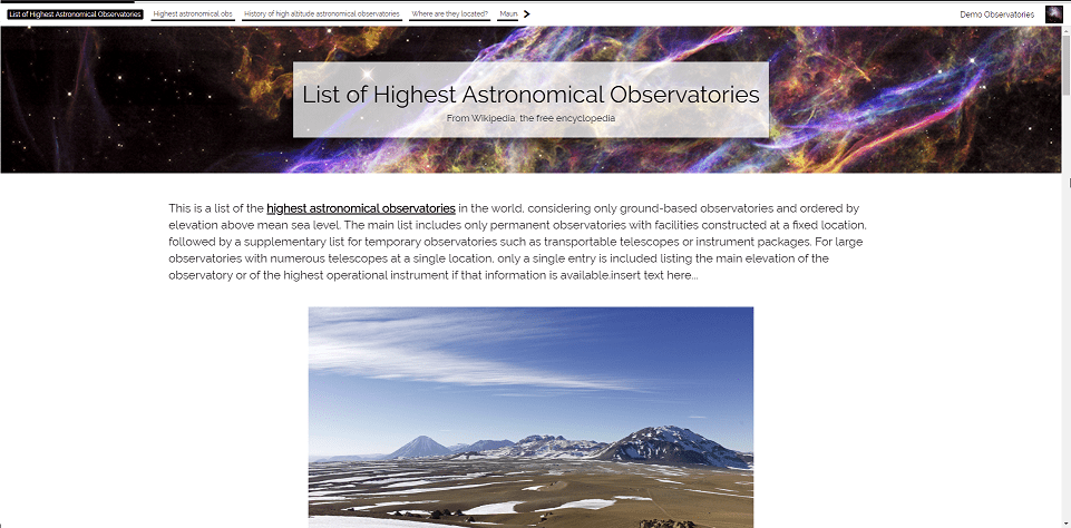
GeoStory – Sample of a story in view mode.
Are you still wondering what GeoStory is? Well, it provides capabilities to tell a geospatial story using existing resource types in MapStore (i.e. Maps and Dashboards). You will notice that a new button is available in the MapStore homepage that allows you to create a GeoStory .

Creating a new GeoStory
If you click on it, MapStore brings you to the GeoStory editor: an advanced web editor that provides a well-stocked set of tools to configure your story. Through this amazing tool, you can build your story by adding different kind of sections, one after the other, organized in a continuous scrolling layout (Scrollytelling). You can add and configure the following sections:
A Media Editor gives you the possibility to easily manage your media so that you can include Images, Videos as well as Maps.

GeoStory – Media Editor.
You can add one of the existing maps in a story or create a new one directly inside the GeoStory editor. In addition you are given the possibility to quickly edit your Map section with an easy to use Map Inline Editor.

GeoStory – Advanced map editor inside a story.
GeoStory gives you control over the sections created through an action toolbar, one per section, as shown in the image below. The action toolbar allows you to perform quick actions on your section’s content.

GeoStory – Section toolbars available
Moreover, the GeoStory editor gives you control over other story parameters and settings through a side panel where you can freely organize your sections by simply using drag&drop. Here you can:
- Scroll to a specific section or rename the section itself, drag and drop a section to change its position inside the story

GeoStory – Side Panel, zoom to a section or rename it
- Open the story settings to configure things like the story theme, the navigation toolbar or other settings as shown below

GeoStory – Settings of a Story
Last but not the least, you can manage your stories, in a similar way that you are already use to do, with Maps and Dashboards. You can manage permissions for specific groups of users, you can share your story, and more. A sample of a StoryMap is available in our MapStore live demo here (you can login with user demo and password 123demoUser).
Special thanks to the Neftex Petroleum Consultants Limited, who funded this new feature.
Creating custom viewers with the Application Context
The Application Context Manager is an administrative tool designed to build and configure different MapStore viewer configurations for the same MapStore installation. Through a multisteps wizard the administrator is able to configure a custom MapStore viewer by choosing:
- The name of the context (the viewer will have its own specific URL)
- The default map configuration and map contents (like layers, backgrounds, catalog sources, the map’s CRS etc.)
- The set of plugins available for the viewer. You can build you own custom plugin and install it in your instance directly using the wizard. We made a sample plugin that is ready for you to test and reuse.
In previous versions of MapStore, there was only a single application configuration with the possibility to define and load additional ones with a specific URL parameter. This is still possible allowing users to define different viewer configurations for the same MapStore instance, but this new development gives the users the possibility to manage different viewer contexts through the MapStore admin user interface.
The Application Context has been conceived to easily create multiple MapStore viewers with a single installation. Each installation has its own set of plugins, look and feel, default map contents and Viewer’s URL.
A user can also create his own maps starting from a context. A new administrative section has been added to open the application context manager from the MapStore home page.

Application Context – Opening the manager from home
The manager allows you to manage your contexts in the same way as other MapStore resources. You can share the context, manage access permissions and properties in the same way you do for Maps, Dashboards and Stories.

Application Context – Contexts manager
Let us now see each wizard’s step in more details.
Step #1 allows MapStore administrators to setup the name of the context (it will appear in the URL of the context) and the browser’s window title.

Application Context – Step #1 of the wizard
In step #2 administrators can setup the default map contents of the context. The image below shows the available tools for setting up the default Viewer’s map.

Application Context – Step #2 of the wizard
In step #3 we can setup which plugins need to be included and enabled in the context viewer. You can:
- Select plugins to enable
- Go to the online plugins documentation to check available configuration properties for a specific plugin
- Configure each plugin through a text area where you can customize its configuration properties (a validator helps you on this)
- Mark a plugin as mandatory for the context or ready to be added/removed on the fly by the user! Look at online documentation to learn more about the user’s Extension Library
- Install your custom plugin by uploading the extension package in zip format!

Application Context – Step #3 of the wizard
If enabled by administrators, a user can save his context maps and browse all maps available in the MapStore catalog through the Map Catalog tool. You do not need to leave the Viewer anymore to switch to other maps!

Application Context – Map Catalog
If you want to know more about this feature, please check the online documentation which covers other functionalities not described of this blog post. For example, Map Templates are ready-made map contents that can be added to a Map.
Special thanks to Renne Métropole, who funded this new feature for the geOrchestra community. We will write a separate blog post about the adoption of MapStore as the geOrchestra viewer.
Ongoing and future work
For the next releases we are working on the following (in sparse order) functionalities:
- Improvements of the Style Editor to improve the user experience when editing styles in MapStore.

Style Editor – Improved UI
- Improvements on the MapStore SDK to simplify the life of developers creating downstream projects like the GeoNode integration.
- Enhancements for the Annotations and Identify tools to improve the user experience with a new user interface and additional capabilities.
If you want to play with the current release, you can access the live demo here and login with username demo and password 123demoUser.
If you are interested in learning more about how we can help you develop a WebGIS using MapStore or help you achieve your needs related to GeoServer, GeoNode and GeoNetwork through our Enterprise Support Services and Subscription Services please contact us!
The GeoSolutions team,
