

MapStore 2026.01.00 Release
We are pleased to announce the release of the new series 2026.01 of MapStore, our flagship Open Source WebGIS product. On GitHub it is possible to consult the full list of new features, enhancements and fixes we have provided in version 2026.01.00 .
We would like to thank all contributors who made this release possible, in particular KFW, Vlaanderen, Total Energies, Genoa Municipality, Cleveland Metroparks and Deutsche Bahn for their valuable contributions (the full list is available at the v2026.01.00 release page in Github).
The 2026.01.00 version introduces a wide range of enhancements focused on dashboard usability, data interaction, advanced visualization, and system flexibility. It represents another important step forward in evolving MapStore into a comprehensive platform not only for geospatial visualization, but also for advanced data exploration and dashboard-driven analysis.
Advanced Dashboard Experience
The v2026.01.00 release brings significant improvements to the dashboard experience, focusing on usability, flexibility, and advanced data interaction. The new features are designed to help users better organize content and build more dynamic and insightful analytical views.
With the new Tabbed View for Dashboards, users can now organize widgets into multiple navigable sections. This approach optimizes screen real estate and makes complex dashboard configurations easier to manage, especially in data-rich scenarios.
Complementing this, the Dynamic Filter Widget Builder introduces a powerful and flexible way to create custom filtering interfaces at runtime. Users can define complex filtering conditions on-the-fly and apply them across multiple connected components such as maps, charts, and tables. This centralized approach significantly enhances data exploration capabilities, transforming dashboards into fully interactive analytical environments.
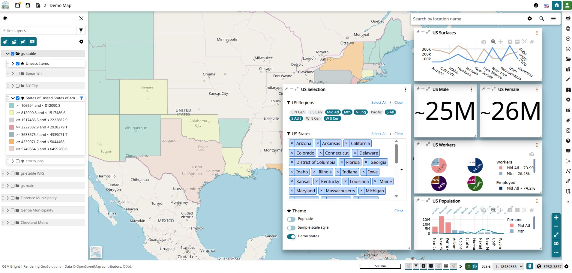
Dynamic filter widget in action
Enhanced Navigation and Map Interaction
This release introduces improvements aimed at enhancing map navigation and user interaction within the viewer. New tools provide greater control over how users explore spatial data, making navigation more intuitive and efficient across both 2D and 3D environments.
Map navigation has been enriched with the introduction of the CameraPosition plugin, which allows users to save, manage, and recall specific viewpoints. This enables seamless navigation across the map and makes it easier to return to predefined points of interest, particularly in 3D environments.

CameraPosition plugin in action
Additionally, a Floating Dynamic Legend for ArcGIS and WMS layers improves the existing legend capabilities by ensuring that legend information is always accessible and dynamically updated based on active layers and the current map extent, improving map readability and user context.
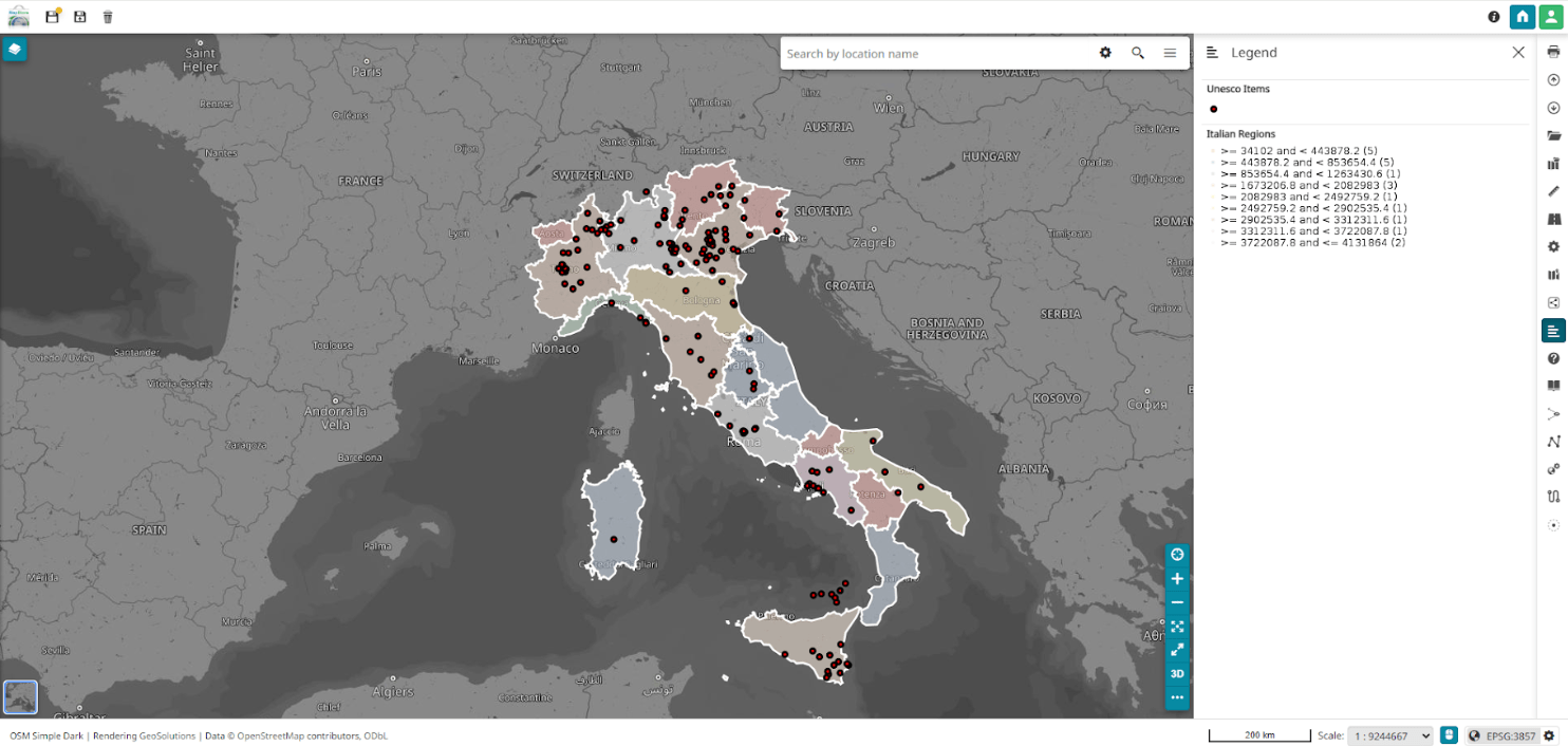
Floating Dynamic Legend in Action
Greater Flexibility in Data Access and Configuration
With the 2026.01.00 release we have completely revamped how MapStore handles request authentication and custom headers. By transitioning from the legacy authenticationRules to the new Dynamic Request Configuration Rules (migration guidelines are available for this), we’ve made the platform more flexible and reactive to security changes.
Key highlights include:
-
Generalized Header & Parameter Injection: The new system moves away from a few fixed “methods” (like just bearer or authkey) in favor of a generalized approach. Administrators can now inject any set of headers or parameters into service requests that match a specific URL pattern.
-
Live Updates via Redux: By integrating these rules directly into the application’s state, MapStore can now update request configurations on-the-fly. This is essential for modern security workflows where authentication tokens need to be refreshed without reloading the entire map or application.
-
Broad Service Compatibility: This new logic is applied consistently across all major data sources supported by MapStore, including standard OGC services (WMS, WFS), Cloud Optimized GeoTIFFs (COG), and 3D Tiles.
-
Simplified Admin Experience: Configuration in
localConfig.jsonis now more intuitive, supporting dynamic variable substitution (such as${securityToken}) directly within the defined headers or parameters.
This architectural improvement ensures that MapStore remains compatible with complex security infrastructures while providing a smoother, uninterrupted experience for users working with secured geospatial data.
Enhanced CRS Selector and Projection Management
In this release, we have significantly improved how users interact with Coordinate Reference Systems (CRS) in MapStore. Handling complex lists of projections is now much more intuitive thanks to a complete overhaul of both the user interface and the backend configuration logic.
Key highlights include:
-
New Dual-Interface UI: The CRS selector has been split into two main components: a Quick Selector for rapidly switching between frequently used systems, and a Settings Modal. This new modal provides a dedicated space to browse the full set of available projections with improved search tools.
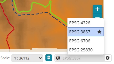
New Quick CRS selector
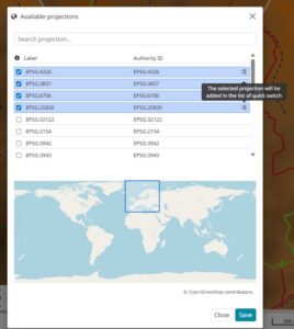
New Advanced CRS management modal
-
Unified Configuration: From an administrative standpoint, we have simplified management within
localConfig.json. The previousfilterAllowedCRSandadditionalCRSparameters have been deprecated in favor of a singleavailableProjectionsconfiguration. This unified approach makes it easier to define filters and add custom CRS in one place, reducing configuration errors. -
Granular Permission Control: We’ve introduced new permission settings that allow administrators to define exactly who can access the advanced settings modal and the quick selector, providing better control based on user profiles.
This update not only enhances usability for professionals working with diverse map projections but also streamlines the setup process for developers and system administrators maintaining the platform.
Improved Data Visualization and Analysis
This release expands MapStore’s capabilities in handling both spatial and non-spatial data.
Support for Cloud Optimized GeoTIFF (COG) has been enhanced, including integration within the 3D viewer and the ability to inspect raster data directly through the Identify tool. This allows for more efficient handling and analysis of large datasets.
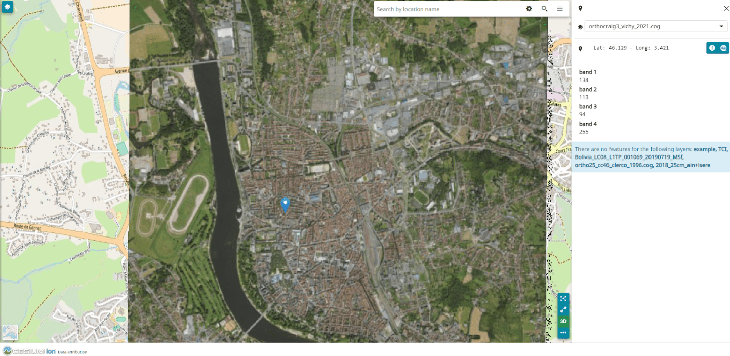
COG Support
At the same time, MapStore now introduces improved support for non-spatial datasets, enabling better visualization and management of tabular data within the platform.
Other major improvements involving data visualization that are included within v2026.01.00 are related to:
- Advanced visualization options such as line traces classification: Introduces support for line traces classification, allowing users to apply more advanced styling and categorization to line-based datasets. This improves the readability and interpretation of complex visualizations, especially when working with mixed or multi-dimensional data in charts.
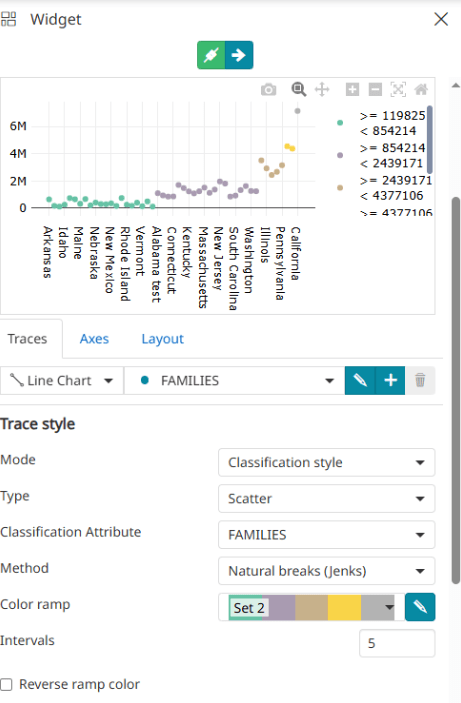
Line Traces Classification for Advanced Chart Visualization
- New editing restrictions in the attribute table for better data control and integrity: working on top of GeoServer GISP-234, this interesting enhancement adds more granular control over attribute table editing by introducing configurable restrictions on data modification. This ensures better data integrity by preventing unintended changes and allowing administrators to define stricter editing rules based on specific use cases or user roles.
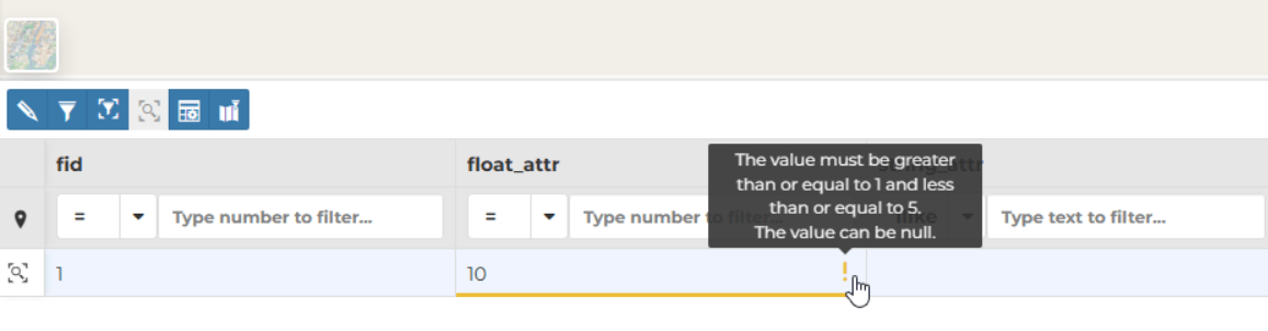
New editing restrictions in the attribute table
Dashboard and UI Improvements
The dashboard and map editor experience has been further refined, with a strong focus on flexibility, usability, and consistency.
Users can now leverage the Attribute Table within the advanced Map editor, improving data inspection workflows and enabling more efficient interaction with map content.
[videopress zpANg9cu]
In addition, with v2026.01.00 the Map Viewer & UI Flexibility improvements introduce a more adaptable layout system, allowing support for different container positions. This enables users to better tailor the interface to their needs and optimize the use of available screen space. At the same time, a general restyling of application buttons improves visual consistency and enhances the overall user experience across the platform.
Aside from the general restyling of the application’s buttons and sidebar, one of the most notable results of the applied layout updates concerns the Widget Tray, now included in the application’s footer for a more compact result and a consequent advantage in terms of responsiveness of the tool. This builds on the redesign process started with the 2025.01 series.

New widget tray
3D Visualizations
MapStore continues to also strengthen its 3D capabilities and tools with several important updates. This release introduces a new global setting that provides better control over imagery layer overlays on 3D Tiles. This enables more effective integration between traditional 2D services and 3D datasets, for example by allowing WMS layers to be overlaid on 3D Tiles.
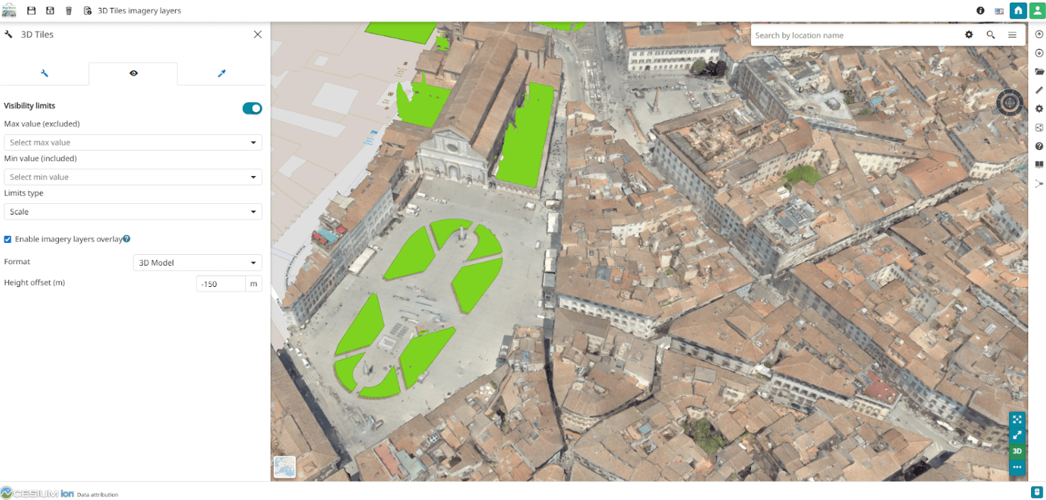
WMS layer overlaying a 3D Tile
Cesium’s zoom logic has also been refined, particularly for small map extents, ensuring smoother and more precise navigation in detailed 3D scenes.
System and Infrastructure Updates
Beyond new features, the v2026.01.00 release brings significant under-the-hood enhancements designed to make MapStore more secure, easier to deploy, and more transparent for developers:
-
Enhanced Security with Tomcat 9.0.116: We’ve updated our middleware stack to the latest stable Tomcat 9 release. This ensures that MapStore environments benefit from the most recent security patches and performance optimizations, keeping your data and services protected.
-
Leaner, Faster Docker Deployments: Our Docker architecture has been refined. By optimizing the Dockerfiles, we’ve reduced image sizes and improved build times. This means faster deployments and more efficient resource usage in containerized environments like Kubernetes.
-
Better Maintainability for Custom Plugins: Thanks to Open-Groupe, a versioning display for custom plugins has been introduced. This feature provides a clear overview of the specific versions of extensions running in your instance, making it much easier for support teams and developers to manage complex, customized MapStore installations.
-
Smoother Developer Experience: We’ve automated several parts of the development workflow to lower the barrier for contributors and speed up the delivery of custom projects. From initial setup to final build, the process is now more robust and less prone to manual configuration errors.
-
Seamless Multi-App Deployments: A common challenge for enterprise users was hosting multiple MapStore instances on a single domain. Previously, sessions could overlap and invalidate each other. With our latest fix for session handling, you can now run multiple MapStore apps (e.g., mapstore.com/city-a and mapstore.com/city-b) side-by-side without any authentication conflicts, providing a seamless experience for users moving between different portals.
All these updates contribute to a more robust and secure platform, while also improving the overall developer workflow and operational efficiency. These are just some of the many improvements introduced in the 2026.01 series, which continues to expand MapStore’s capabilities as a modern, flexible, and powerful WebGIS platform.
Stay tuned for future updates as we continue to enhance the MapStore project with new features and improvements in upcoming releases.
If you are interested in learning more about how we can help you develop a WebGIS using MapStore or help you achieve your needs with MapStore, GeoServer, GeoNode and GeoNetwork through our Enterprise Support Services, Professional Training Services and Subscription Services please contact us!
The GeoSolutions team,
